What you'll find in this section
Data about
- Food deserts
- People receiving SNAP benefits
- Populations at risk of low food security
Key Findings
- A total of 20,500 people live in food deserts
within the five-county region. 15,300 live
in Vanderburgh County and 5,100 live in
Henderson County. - Old Erie, Ballard, and Bellemeade Bayard Park are home to a combined 2,768 people living in a food desert.
- One of the largest food desert populations
is located near Lynch Road and Interstate 69, where 2,379 people live in a food desert in this census tract. - Henderson County has the highest food
insecurity rate (17.0%). this is higher than the
national rate of 13.5%. Vanderburgh County
also has above average food insecurity (14.9%).
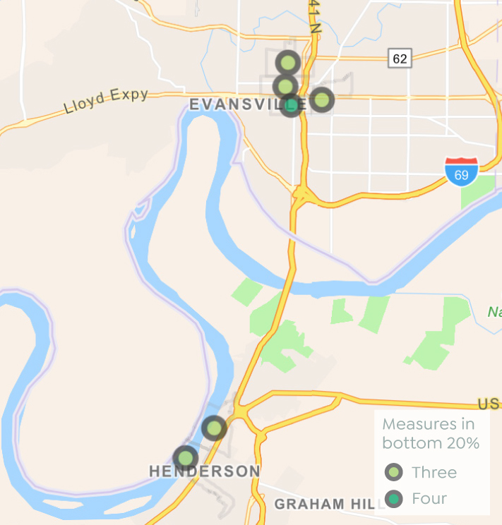
Where you live matters
These areas ranked in the bottom 20% for at least three of these statistics: total population living in a food desert, percent of population far from a grocery, percent of households receiving SNAP, and percent of population living below 185% of the poverty threshold.
This chapter considers two dimensions related to food: food access and food security. Food access encompasses many factors, but in this report we measure the proximity to grocery stores and the physical ability of residents to access healthy food retailers. Food security analyzes the financial ability of families to afford the food they need.
Food Access
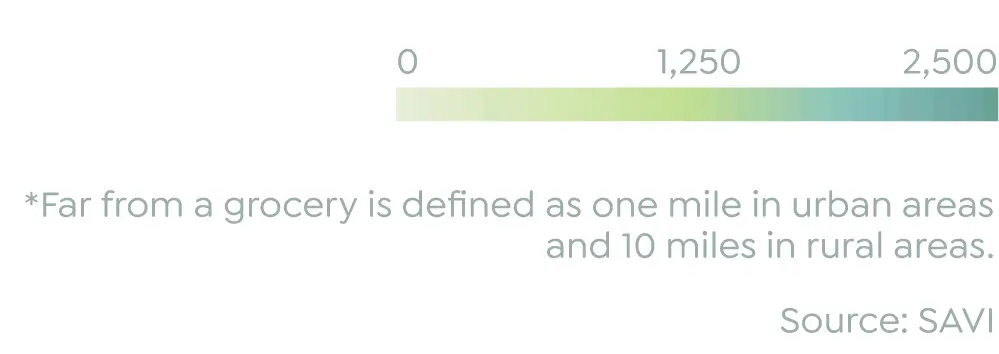
Food access is often measured in terms of “food deserts.” A neighborhood is identified as a food desert when it is both a low-income area and has low access to grocery stores. Low-income areas have a poverty rate of at least 20% or a median household income that is 20% lower than the region’s. Low access to a grocery store means at least one third of the population lives further than a one-mile drive from a full-service grocery store that sells fresh food, including produce.
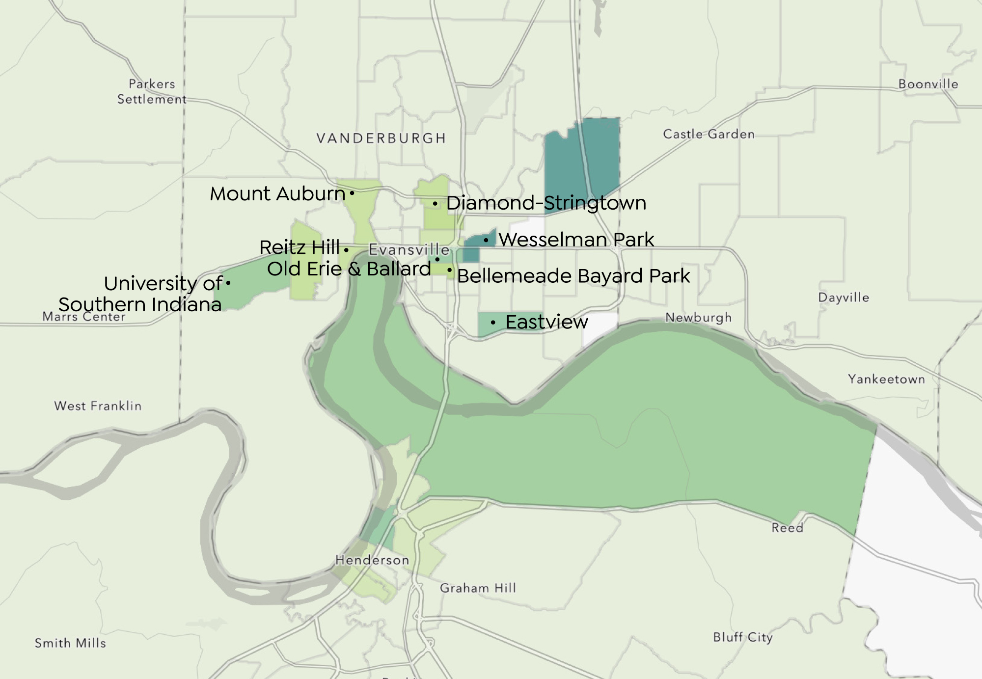
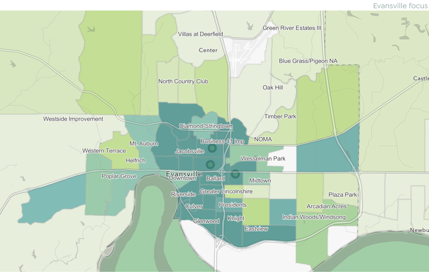
Map: Population Living in a Food Desert
Living within census tract designated as a food desert and living more than one mile from a grocery*
Click here to explore map in SAVI
The tract with the largest food desert population is near Wesselman Park and the University of Evansville, where 2,468 people live in a food desert (71% of the population in that tract).
One of the largest food desert populations is located near Lynch Road and Interstate 69, where 23% of the population lives in poverty and 84% of residents are far from a grocery. In total, 2,379 people live in a food desert in this census tract.
Other prominent food deserts include Mount Auburn, Reitz Hill, Eastview, and neighborhoods east of University of Southern Indiana. In the center of the city, Old Erie, Ballard, and Bellemeade Bayard Park are home to a combined 2,768 people living in a food desert. Diamond Stringtown and downtown Henderson, Kentucky are also significant food deserts. In total, 18 census tracts contain food deserts. A total of 20,500 people live in food deserts within the five-county region. 15,300 live in Vanderburgh County and 5,100 live in Henderson County.
Food Security
Food security is measured by a U.S. Department of Agriculture survey at the state and national level, but there is no food security survey at the county of neighborhood level. Feeding America’s Map the Meal Gap report estimates county-level food security by assuming that drivers of food insecurity at a state level are also drivers at a local level.1
Henderson County stands out as having the highest estimated food insecurity rate. At 17.0%, this is higher than the national rate of 13.5% Vanderburgh County also has above average food insecurity.
While the other counties fall below the national average, the range of food insecurity is not that broad—in every county, one tenth to one sixth of the population is food insecure. Even in wealthier counties there are low-income populations who have a hard time affording food.
These rates correlate with the share of households receiving SNAP benefits. The highest rates are again in Henderson and Vanderburgh Counties. There is a gap in every county between the share of people estimated to need food assistance and the share that receive food assistance. This gap is actually largest in higherincome counties. In Warrick County, while 10.8% are estimated to need food assistance, only 4.1% receive SNAP benefits, leaving 6.5% of households with low food security and no benefits. Some of the known hindrances to benefit uptake are stigma and a lack of information.
On a neighborhood level, income is an excellent proxy for food insecurity. Because is food such a priority in every households budget, the obvious driver of food insecurity is poverty. Nationally, 38% of households under 185% of the poverty threshold have low food security. Only 9% of households with higher incomes have low food security.2
Regionally, most of the highest concentrations of low-income households are in Henderson, Kentucky and Evansville. About half of downtown Henderson residents are below 185% of the poverty line. In most neighborhoods in the core of Evansville, at least 45% of the population lives below 185% of the poverty line. Southeast of Jacobsville, the rate climbs to 60%. The rate is 64% in northern Jacobsville and 70% in southern Jacobsville. In Goosetown and Culver, the rate is 57%, and in Tepe Park 58% of the population have incomes below 185% of the poverty threshold. In the tract containing Riverside and Center City Improvement Association (CCIA), the rate is 47%.
Henderson and Vanderburgh Counties have highest rate of food insecurity
Estimated percent of population with low or very low
food security
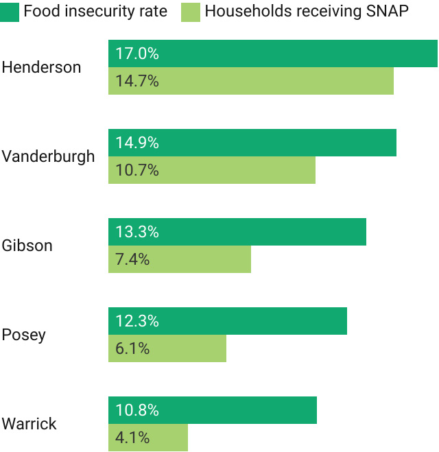
Source: Feeding America, U.S. Census Bureau
Map: Low-Income Population
Percent of population with household income under 185% of federal poverty threshold

Click here to explore map in SAVI
Notes
- Feeding America. How We Got the Map Data. 2023. Accessed from: https://www.feedingamerica.org/research/map-themeal- gap/how-we-got-the-map-data
- Rabbitt MP, Reed-Jones M, Hales LJ, Burke MP. Household Food Security in the United States in 2023. 2023. U.S. Department of Agriculture. Accessed from: https://www.ers.usda.gov/webdocs/ publications/109896/err-337.pdf?v=4222.2
Where You Live Matters is a product of Grow
in partnership with The Polis Center.
Guide