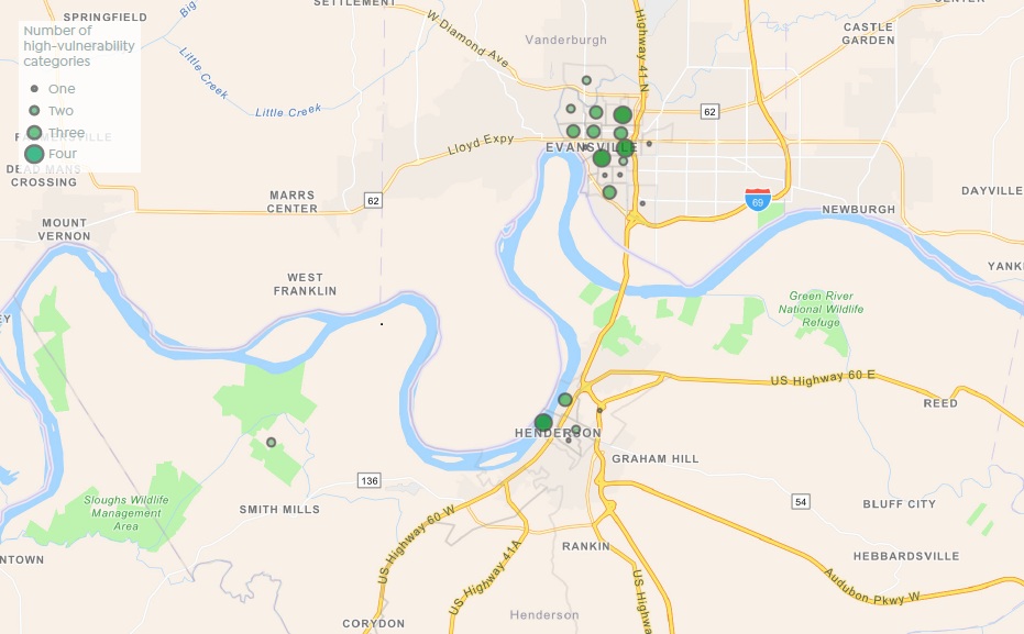
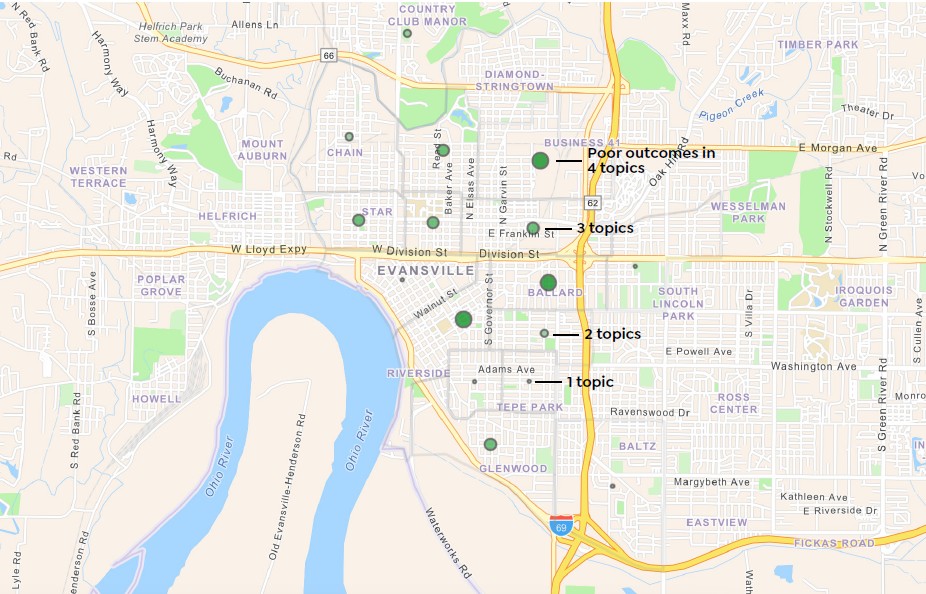
Four neighborhoods had high measures of vulnerability in four of the five topics.
Northeast Jacobsville. This area has low food access, poor health outcomes, high environmental burden, and high housing cost burden. This census tract, bounded approximately by Columbia Street to the south, US 41 to the east, Morgan Avenue and Reis Avenue to the north, and Heidelbach Avenue to the west, is home to 2,200 people.
Nearly a quarter of residents have more than 14 days per month with poor mental health, and an estimated 29% have been diagnosed with depression at some point. One-in-four residents live with a disability, while 16% have been diagnosed with diabetes at some point. Most residents here are renters, and 42% of households are burdened by costs.
This area has a higher total environmental burden than 96% of U.S. census tracts, with worse air pollution than 81% of U.S. and worse point-source pollution than 88% of U.S. About half of residents live in a food desert.
Old Erie and Ballard. This area has low food access, low socioeconomic status, high housing cost burden, and poor health outcomes. This census tract, bounded by Lincoln Avenue to the south, Willow Road to the east, Lloyd Expressway to the north, and Governor Street to the west, is home to 1,900 people.
Just like in northeast Jacobsville, nearly one quarter of residents report more than 14 days per month of poor mental health. Nearly one fifth (18%) of residents have been diagnosed with diabetes at some point. Only one third of households own their home in this neighborhood, and 43% are burdened by housing costs.
This area is a food desert—84% of residents live in a food desert in this tract. Incomes also tend to be low. The median households income is S34,000 per year, while 32% of residents live below the poverty threshold. The unemployment rate is 9.2%.
CCIA (Center City Improvement Association). This census tract, which is bounded by Powell Avenue and Shawnee Avenue to the south, Parrett Street and Governor Street to the east, Walnut Street to the northwest, and the Ohio River to the southwest, is home to 1,700 residents. This census tract has high housing cost burden, high pollution, poor health outcomes, and high poverty and unemployment.
The unemployment rate in this area is estimated at 20.8%, significantly higher than other neighborhoods. More than one third of residents live below the poverty threshold. The area’s environment ranks worse than 95% of the U.S., principally because of high air pollution and high point-source pollution.
About one-in-ten adults here have been diagnosed with heart disease at some point, and over a quarter with depression. Almost four- in-ten adults live with a disability. In terms of housing, housing values are very low here—the median rent is S659—but most households (51%) are housing cost burdened.
Downtown Henderson. This census tract is mostly bounded by Elm Street and Green Street to the southeast, the CSX Railroad to the northeast, the Ohio River to the northwest, and Audubon Street to the southwest, though a portion between Clay Street and Vine Street extends to Osborn Park. The population of this area is 2,300, and this area has low food access, low home ownership, poor health outcomes, and low socioeconomic status.
Thirty percent of adults report being diagnosed with depression at some point, and 36% live with a disability. Despite low rent values (median is S740 per month), nearly half of households are burdened by housing costs. The poverty rate here is extremely high (39%) while the median households income (S27,785) is the third lowest in the region. Over 500 residents live in a food desert and three-in-ten utilize SNAP benefits.